The house is from 1926. In the basement, there is a smaller room where the floor is raised by about 25 cm. I imagine that there once stood a boiler there. This room is my "workshop." I was thinking of chiseling down this ledge/elevation to gain full height in the room.
We had an inspector over to check a few things, and he mentioned that he wouldn't be surprised if there was a rock formation under this elevation. I was completely sure it was a raise for the boiler's function...
Now to the question: How do I find this out without starting to chisel down the ledge?
I have thought that if I drill with the chisel machine, in four holes at strategic places in the room, I should be able to reasonably notice the difference between granite and 100-year-old concrete. Either it will suddenly become rock-hard, or I will sink down to the desired depth?
What does the collective brainpower think? Anyone with experience in similar operations?
The house is from 1926. In the basement, there is a smaller room where the floor is elevated by about 25 cm. I imagine that a furnace once stood there. This room is my "workshop." I was thinking of breaking down this slab/elevation to have full height in the room.
We had an inspector at home to check a few things, and he mentioned that he wouldn't be surprised if there was a rock bed under this elevation. I was completely sure it was an elevation for the furnace's function...
Now to the question: How can I find this out without starting to chip down the slab?
I have thought that if I drill with a demolition hammer, in four holes at strategic spots in the room, I should reasonably notice the difference between granite and 100-year-old concrete. Either it becomes suddenly very hard, or I sink down to the desired distance?
What does the collective brainpower think? Anyone with experience in such operations?
The house is from 1926. In the basement, there is a smaller room where the floor is raised by about 25 cm. I imagine that there once was a boiler there. This room is my "workshop." I was thinking of chiseling down this ledge/elevation, so that the room would have full height.
We had an inspector at home to check some things, and he mentioned that he wouldn't be surprised if there was bedrock under this elevation. I was completely sure it was an elevation for the boiler's function...
Now to the question: How do I find this out without starting to chisel down the ledge?
I've thought that if I drill with the chisel machine, at four holes in strategic places in the room, I should reasonably notice a difference between granite and 100-year-old concrete. Either it suddenly becomes rock hard, or I sink down to the desired distance?
What does the collective brain power think? Anyone with experience in such operations?
Yes, you can observe the drilling speed and resistance.
You can also look at the color of the drilling debris. Modern concrete tends to be gray. Older concrete can have a lot of stones in it, making it harder to distinguish from solid rock.
Drilling depth. Can you drill more than 10cm below the adjacent floor level without hitting something softer?
You can check SGU's maps for the expected rock type underneath. You can break a smaller area with wedges without any problem regardless of the type of rock.
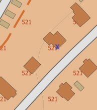
The map viewer was quite difficult to navigate. Unfortunately, I can't find anything useful there. In the picture, the mentioned room is the blue cross.
I don't have any old drawings. Is it the Land Survey or the City Archive that should be contacted, or something completely different?
It seems that drilling is necessary. I'll call the municipality tomorrow and check, maybe I'll get lucky.
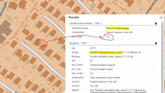
No, exactly. You have to click on the map, and then some geological information will appear. I can't guess where you live, but I clicked somewhere in the 521 area and got the following:
Variants of gneissic granite are common around here. As long as the gneiss planes aren't extremely bad, it usually works to crack and chip away.
The Swedish Mapping, Cadastral and Land Registration Authority and the municipality aren't useful. Foundation details are hardly in the municipality’s archives, and such old ones usually have very scant information anyway.
Go ahead and drill, or rent a jackhammer and roll up your sleeves!
If it gets too terribly messy, you might have to pour concrete back in a ledge.
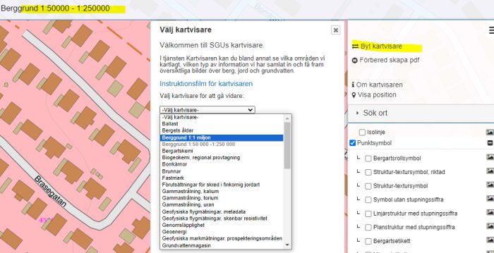
Edit: Bedrock 1:50 000-1:250 000 provides better info than 1:1 million, switch to that. There you can also switch over to the soil map, soil depth map, and well archive and look at their information on how deep it is to the bedrock (in the well archive you click on a well, and the depth to bedrock is in one of the fields in the popup).
In this case, it's the soil map 1:25000 that you should look at, if you're not particularly interested in exactly which rock type it is.
However, note the scale. Neither the soil map nor the bedrock map have such resolution that they can say anything at the property level (even less so for different parts of a building), often not even at the block level. The base data is of varying quality, and the boundaries between different soil types accordingly. But you can, of course, get an indication. If you live right in the middle of a gravel ridge, a clay valley, or directly on a larger area of bedrock, you'll naturally get a likely answer.
Click here to reply
Vi vill skicka notiser för ämnen du bevakar och händelser som berör dig.
andreascarlsson said:
The house is from 1926. In the basement, there is a smaller room where the floor is elevated by about 25 cm. I imagine that a furnace once stood there. This room is my "workshop." I was thinking of breaking down this slab/elevation to have full height in the room.